
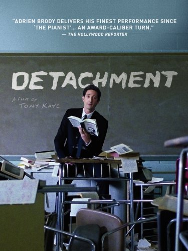
And now from our “Wow” files, here’s the Romotow T8.
The Romotow T8 RV is the brainchild of W2, a New Zealand-based architecture and design firm.
See the video:

Though this thing is a definite beauty, I’m not sure if I would ever be able to get it to fit in some of my favorite camping spots here in Montana — I may wish to bring a chainsaw along for just in case that one big tree is in the way … just kidding.
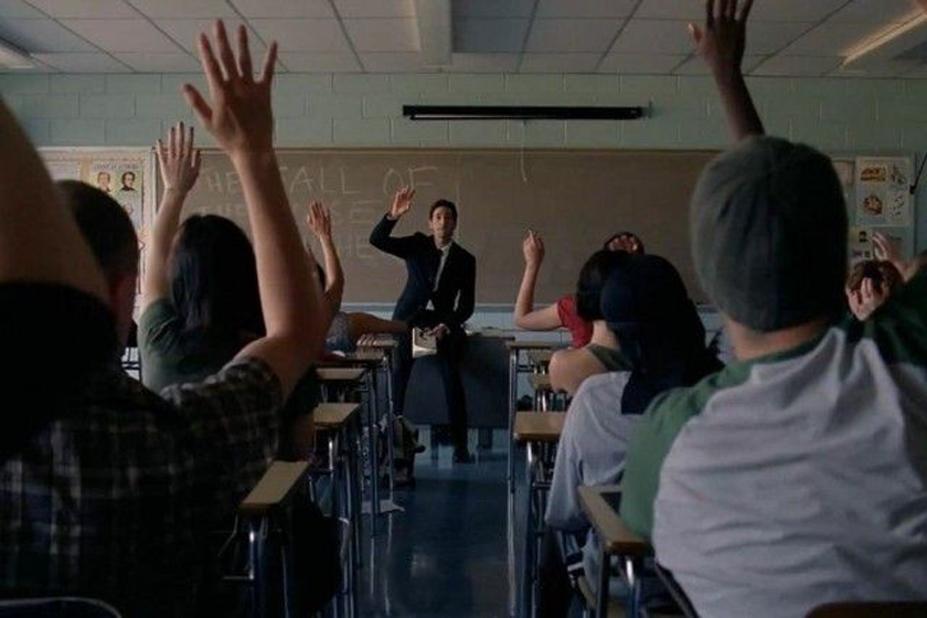
The most striking feature of this RV is its rotating cabin, which can swivel 90 degrees from its shell when parked. Inside the rounded front nose are removable canvas/mesh sidewalls to keep the bugs out.
The rotation is controlled by an automated hydraulic system that makes the process smooth and easy. You don’t need any special skills or tools to operate it, just a hitch to tow it and a button to transform it.
This RV is constructed with a lightweight carbon fiber chassis and composite body for durability and better tow vehicle fuel efficiency. Weighs approximately 7,700 lbs.
It also has power and Off-Grid capability: Equipped with a 395W solar panel and a 200-Ah lithium battery, with options for additional panels, battery capacity, and an inverter.
This unit includes a C-Zone app-controlled electrical system, optional 32-inch 4K smart TVs, an outdoor projector with an 82-inch screen, and a multi-zone Fusion audio system.
Luxury finishes like teak joinery and acrylic countertops are available.
It costs about $260K, which is more than some houses. But according to co-founder Matt Wilkie, the Romotow T8 is well worth the investment.


Elite Universities received $45 billion in public funds since 2018
Originally published by Adam Andrzejewski — January 30, 2024
Topline: You might expect that your tax dollars are being used to fund public universities, and that elite, private institutions are able to hold their own with little government support.
That’s not the case. Auditors at OpenTheBooks.com found that 10 of America’s wealthiest colleges have received $45 billion in federal money since 2018. That figure includes $33 billion in contracts and grants and $12 billion in tax breaks.
The list includes the eight schools of the Ivy League, as well as Stanford University and Northwestern University.
Key facts: The 10 universities collectively received more money from the federal government than from undergraduate tuition.
Stanford University benefited the most, taking in $7 billion in taxpayer money. Columbia University was the biggest recipient of direct grants, earning $5 billion.
Because the universities are considered charitable institutions, they pay just a 1.4% tax rate on increases to their endowments, instead of the typical 20% capital gain tax for wealthy individuals. This policy benefited Harvard University and Yale University the most, since their endowments both increased by more than $11 billion between 2018 and 2022.
Some of the grants were used to fund research studies with arguable merit. One Stanford study use almost $2 million to analyze how college students are affected by retail marijuana. Yale used $600,000 to look at the “impacts of mobile technology on work, gender gaps, and norms.”
Background: The $45 billion that the 10 universities received since 2018 is larger than any U.S. public universities’ entire endowment. The University of Texas led public schools with a $43 billion endowment, as of 2021.
Five of the 10 universities included in the OpenTheBooks audit were also among the top 10 in the country at generating private donations in 2018, right before the audit began. So, it’s not as if they were strapped for cash.
Auditors found no significant difference in the amount of federal money doled out to elite institutions between the administrations of Presidents Joe Biden and Donald Trump.
Many elite institutions have come under fire in recent months, with some top Republicans claiming that the schools are spreading antisemitism. Trump called for an increase in taxes on these universities’ endowments, while presidential candidate and former SC Gov. Nikki Haley said federal funds should stop being dispersed to these schools.
In December, Sen. J.D. Vance (R-Ohio) introduced a bill that would levy a 35% tax on any college endowments above $10 billion.
Summary: Even with recent controversy, it’s still unknown when or if federal funding to elite, private universities will decrease. It’s hard to ignore the fact that these colleges are at the forefront of both the educational and scientific fields, but the impact on taxpayers also can’t be dismissed.
The #WasteOfTheDay is brought to you by the forensic auditors at OpenTheBooks.com
sourced –
This article was originally published by RealClearPolitics and made available via RealClearWire.