
Forty Acre Bog on Lake Chippewa, also known as the Chippewa Flowage, represents a remarkable natural phenomenon where a floating bog, complete with mature trees, occasionally drifts around the lake. This unique feature of Lake Chippewa was formed when the area was flooded in 1923 to create the lake, resulting in submerged peat bogs rising to the surface. Over time, these floating islands have become platforms for various vegetation, including trees, which can act like sails, moving the bogs with the wind.
See the video:
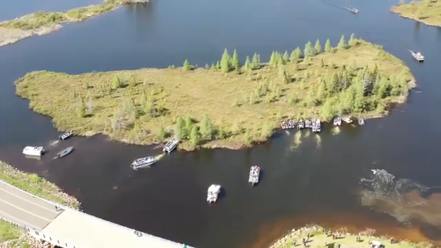
Here are some key points about the Forty Acre Bog:
Nearly every year, local boat owners come together to manually push this floating island away from a bridge connecting the east and west sides of Lake Chippewa. This task is necessary to keep the waterways open, as the bog can block this crucial passage.
The bog, and similar floating islands in the lake, are ecologically significant, hosting various plant and animal species. Their movement around the lake can influence local ecosystems by creating or altering habitats.
The annual event of moving the bog has not only become a community activity but also a point of local pride and interest, drawing the kind of attention where people share videos and discussions online about this natural marvel.
As the name suggests, the Forty Acre Bog is significant in size, covered with vegetation, including mature trees. Its mobility is due to its floating nature, supported by peat that didn’t decompose due to water-logging, making it buoyant.
While the movement of the bog might seem like an inconvenience, it’s also a reminder of human interaction with natural environments. Various discussions often touch on themes like environmental management, the balance between nature and human activity, and even whimsical ideas like establishing a new sovereign nation on the floating land.
The Forty Acre Bog’s story is not just about a natural phenomenon but also reflects human adaptation and interaction with their environment, showcasing both the challenges and the community spirit it fosters.
Note:
Lake Chippewa, also known as the Chippewa Flowage, is an artificial lake in northwestern Wisconsin. It is fed by the East Fork Chippewa River and the West Fork Chippewa River. Winter Dam at the southern end is where the Chippewa River flows out of the lake.
There are numerous floating peat bogs in the lake, the largest of which is known as the Forty-Acre Bog.
Lake Chippewa – Wisconsin DNR


Ryan Busse: Candidate for Montana Governor
Ryan Busse is running as a Democratic candidate for the position of Governor of Montana in the 2024 election.
See video: Ryan Busse for Montana – Let it Fly
Here are some key points about his campaign and background:
Busse grew up on a family cattle ranch and wheat farm and has experience in the firearms industry, where he worked for over 25 years, notably as an executive who helped build Kimber America, an American gun company. However, he has since become critical of the gun industry’s direction, especially after leaving in 2020, and has written a book titled “Gunfight: My Battle Against the Industry that Radicalized America.”
Busse positions himself as an advocate for all Montanans, emphasizing a return to what he describes as traditional Montana values against what he perceives as a shift towards catering to the wealthy under the current administration.
His campaign focuses on issues like:
Affordable housing, particularly aiming at ensuring community heroes like law enforcement, teachers, and nurses can afford to live where they work.
Protecting public lands and the environment, highlighted by his sons’ involvement in the Held v. Montana climate lawsuit.
Defending personal freedoms, including a woman’s right to choose, in light of Montana’s legal stance on abortion.
Addressing property tax increases and advocating for a tax system that he believes would be fairer to middle and lower-income Montanans.
Busse’s campaign includes critiques of the incumbent Governor Greg Gianforte, accusing him of making Montana less affordable and less free, while also emphasizing his own moderate Democratic stance, which might appeal to a broad electorate in Montana, a state with conservative leanings but where Democrats have historically found success with a certain brand of centrism.
His running mate for Lieutenant Governor is Raph Graybill, known for his legal background and previous candidacy for Attorney General.
Busse faces the challenge of unseating Greg Gianforte, who has significant personal wealth to fund his campaign and whose party has been dominant in recent Montana elections.
Busse’s campaign is notable for its attempt to blend traditional Democratic values with a strong appeal to Montana’s cultural heritage of outdoor life, personal freedom, and community values, potentially aiming to bridge the gap between urban and rural voters.
To learn more about Ryan Busse visit his website: https://busseformontana.com/
Note:
Raph Graybill served as chief legal counsel to Steve Bullock, the governor of Montana, from 2017 to 2021.
Graybill was a candidate for attorney general of Montana in the 2020 general election.
Currently, Graybill is running for lieutenant governor in the upcoming 2024 gubernatorial election in Montana.